

Book 2 - Ch 44
Book 2, Chapter 44
I skipped my exercise run this morning but Dad joined me for an early breakfast then drove me to the station for my 05:55 train to Southampton.
“I wish I was coming with you today,” said Dad as I described the plan to join a freighter at Southampton on the south coast and sail to Sheerness at the entrance to the Thames Estuary. All told it was about 200 nm through the busiest shipping channel in the world. I tried to nap a little on the train knowing I would probably be awake all night but it wasn’t to be. Whoever said the English don't talk on trains was either from a different era or was never an 18 year old girl!
Luckily when I changed trains at Reading station I was given some peace to get into Tracks by Robyn Davidson which I'd borrowed from Litara’s bookshelf. By the time Jeannie met me at Southampton station I felt much better informed about the idiosyncrasies of camels and travelling solo across deserts which might or might not help me on my journeys but had kept me absorbed.
Jeannie checked me out as we walked to her car: my hair I'd put in a simple tidy French twist as I felt life on a freighter was probably like life in the Royal Navy and pretty formal. That was the limit of my naval aspirations as though I carried my foul weather jacket and wore my deck shoes for grip aboard ship my trousers were yellow and I wore a cream Guernsey jumper.
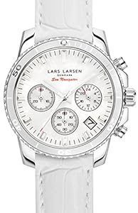
Jeannie gave me an inspection which included a twirl then handed me a gift wrapped package. Opening it gently I had no idea what to expect when under the paper appeared a box and a card saying ‘To my Navigation Teacher from her friend at Greenwich’
“Go on! Open it!” Jeannie was if anything more excited than me when in the box I found a beautiful Navigators Watch. I quickly put it on my left wrist noting that the off white of the strap matched my jumper then turned to Jeannie for an explanation.
“It was delivered to the producer yesterday and she asked me to pass it on to you.”
I imagined it was a gift from the expert who had gone out into the Thames Estuary with us last Monday evening but I couldn’t think what I had taught him to deserve such a gift - I didn’t even know his name to thank him.
Do you want to feel like a god? All you have to do is arrange to stand at the helm of a large ship in a narrow waterway. Failing that stand on the roof of an apartment block and imagine steering it down the road. Although Jean Luc was kept busy with his camera I was very much a passenger as the container vessel made it's way down Southampton Water, through the Solent and into the English Channel heading east.
Except for relatively small cruise ships I’d never seen a large ship next to something that conveyed a sense of scale. This one was mind bogglingly huge compared to an ant like creature like me. It couldn’t even enter most ports and those docks it could use were in very industrial areas and not the sort of places people wandered at will. I guessed our height above the water on the bridge as at least 100 feet but it could have been much more - I tried to imagine my local 50 metre swimming pool as a guide and it felt close. The containers I saw were the same as those I saw carried one at a time on trucks but here there were… I made a rough count of containers along and across the ship and multiplied those by my guess as to how deep they were stacked… 1500? Could that be right? The equivalent of a convoy of 1500 trucks!
As we moved up the English Channel the navigation officer tried to explain all of the equipment while at the same time comparing what the screens showed to our course as kept up to date on a series of paper charts in the same way I would have plotted a yacht's course.
“Charting the oceans has been going on for centuries but modern instruments using very accurate position data from satellites are enabling us to bring the data together in a way we couldn’t have dreamt of a few years ago. To give you an example you could easily make a useable map of the street you live on but to turn a collection of such maps of individual streets into a city map takes more accurate measurements. When I started navigating with a sextant there were still islands in mid-ocean placed miles out of position on the chart because without good clocks the early navigators couldn’t accurately measure the latitude and longitude of such an island: that’s why it took so long to find Pitcairn and the descendants of the HMS Bounty mutineers. Now with GPS we can measure our position to within a few metres so that the many local charts can be corrected and joined together to give an accurate world chart. Our own position and velocity can be shown on that chart and the result displayed on a computer screen like this.
“Why are you still using paper charts if this electronic chart is so accurate? If what the screen shows is true then the electronic chart is much better than your paper plotting as it’s updated continually. We can even see on the computer screen moment by moment if the wind or a current is pushing us off the course we’re trying to steer.
“It is accurate but the electronics isn’t as reliable as people yet plus, of course, I would get out of practice if I only plotted our course when the electronics broke down. Just as important in a way, we wouldn’t be insured if we hit something while relying on just an electronic chart.”
I hadn’t even considered the matter of insurance. Was Dumblebit insured for me to sail?
“If the insurance companies aren’t ready to accept chartplotters do you think they see them as something likely to cause problems?"
“It will take some years before chartplotters are reliable but I imagine one day the insurance companies will accept them and eventually ships will be run like aircraft are today with a ground control ashore and fewer or even no people aboard. Before that though I imagine there will be ships sunk while cutting too close to hazards through overconfidence and even collisions between ships caused by two vessels both being able to stay on the same identical, supposedly perfect route.”
It was spooky to think there might one day be ships this size sailing the oceans unmanned to make their deliveries. How would yachts cope? Although they were not easy to spot at any distance, we’d seen several yachts crossing the shipping lane as they sailed between England and France and the thought that we could swerve to avoid hitting a yacht or anything else seen at the last moment was clearly ludicrous. How good would an unmanned ship be at spotting yachts and other uncharted hazards in time to avoid them?
“That’s Beachy Head,” called the navigation officer breaking me out of my morbid thoughts of collisions. It was nearly dusk but the white, chalk cliffs of the Seven Sisters marching East toward Beachy Head glowed, warming my heart after too much technical talk.
“Do you mind if I take an evening sextant sight,” I asked.
“Of course not if you will let me join you with my sextant.”
The planet Venus being an evening star that week, as dusk fell on a perfect day we made a game for Jean Luc's camera of the two of us taking our sights. I used my new watch after a check against the radio time-signal proved it to be correct to to within a second of Greenwich time and, Venus in the sky together with the watch on my wrist felt like good omens for my sailing days to come. Today, although I was beaten on the speed of my calculation by the navigation officer as I wasn’t as used as he to making the adjustments required when travelling at 20 knots 100 feet above sea level, when I did eventually complete my sums, the perfect conditions resulted in my marked position being within 2 miles of where the electronic chartplotter had us positioned when I was taking my last sight. The navigator's fix on the other hand was 3 miles off so I claimed victory in extra time.
Through the night we moved with ships’ lights moving everywhere as the channel between England and France became narrower. The captain was on the bridge right through the Straits of Dover and my prediction that I would get no sleep proved true. ‘Thank goodness I’m not in charge,’ I thought as I listened to the captain talking to other ships and the Coastguard on the radio and as I looked at jottings made regularly on the chart updating the speed and direction of other ships seen on the radar screen. Twice high-speed ferries crossed our paths and I couldn't help but admire the professionalism that kept both the ships and the masses of people on the ferries safe from harm.
Eventually on the chart I could see the channel widening again as our course became first more northerly then easterly as we made our way up the Kent coast and, with dawn, felt our way into Sheerness docks on the Thames Estuary. This was where the film crew and I had to leave but the experience would leave a lasting impression that a yacht in a shipping lane was taking its life in its hands and I would be steering Dumblebit as far clear of big ships as I could.
Jeannie seemed to be combining her wardrobe duties with taxi driving on this shoot because she was waiting for us at the dock. Our thanks to those with whom we had shared the ship's bridge were completely sincere as, for me at least, it had been a window onto a world an utterly beyond my imagination which is why I looked back and waved as we sped toward London.
The director had claimed by seniority the passenger seat but I could have slept anywhere which is why when an hour later I was woken at the Victoria Dock apartment of Litara’s friend I found that I'd been warmly snuggled into Jean Luc’s side with his arm around me.
Comments
Oh Yes!
Jean Luc's arm around her????? Hmmmmmmmmm.
I have some paper charts framed and one is of the South Sea Islands and apparently they used to navigate using the conspicuous wrecks as navigation marks (daylight only).
Will he!!
Christina
Charting the charts
I've used charts marked:- ‘Last surveyed by HMS Beagle’. It is frightening how many wrecks are on some charts.
Re ‘Will he?’…. I couldn’t possibly say…
Rhona McCloud
Rhona,
Rhona,
Pretty much the same for maps of various regions of the U.S., and I am sure in nearly any country on the planet.
I used to do air/ground search and rescue with the U.S. Civil Air Patrol back in the very late 1950s, early 1960s and into the 1970s; and taught some of that as well.
The maps we had available to us back in those days, were often dated from the 1930s and 1940s, with a very small few in the 1950s.
Once we were searching for a downed CAP aircraft that was carrying a doctor to Mt. Rainier (Washington State) for a medical emergency. The plane disappeared and when we went searching for it, we actually found 8 previous aircraft wrecks; of which only TWO had known locations on any of our maps.
One wreck dated back to when the B-17 bomber airplane was first designed and being test flown by The BOEING Airplane Company. All anyone back then knew was it had gone down "somewhere" and was missing.
This was back in the 1930s; we found it in 1958.
We finally located our plane approximately three weeks later, half way up the side of Mt. Rainier. Sadly with both the pilot and doctor deceased.
GPS today has become a true boon to both sea travel and air travel, plus land travel.
As mentioned by the ship navigator, the maps must be constantly updated to ensure all travel is safe and secure as can be.
Janice
History is still with us when times change so quickly
I come from a densely populated region (UK) and think it surprises us more when crashed planes aren't found. Even in 2007 California it was 13 months before Steve Fossett's remains were found by chance. Despite that I had a surprise visit in the Arctic because I was spotted on a satellite photo and a neighbour from 20 miles away dropped in to say hello.
Rhona McCloud
whoohoo! Snuggling into Jean Luc's side!
Insite into how the big ships operate and what they can and can't do when sailing will be invaluable during Venus' s up coming voyage! Another fine chapter hon! Loving Hugs Talia
Missing aircraft
The first crossers of the Atlantic were Nussenger and Chollie (I can't spell cat) they flew over the Maine coast and went down in the fog. A hunter found their wreck years later, but, could never find the way back. This was before the Spirit of St Louis took off for France. History changed.
Great story
Kevin